Volcanoes National Park and Lassen Volcanic National Park had been added to the been-there-done-that list but somehow that fascination for volcanoes just refuses to die. One time when we had some time on hand while we were returning from Seattle, I suggested we go have a look at Mt. Rainier on the way. That was a whole other story. We’ve been there but didn’t get to see the biggest volcano of the Cascade Range.
Some time later, I happened upon a list of scenic routes in Washington and on it was the Spirit Lake Highway that went up to Mount St. Helens, another volcano in the state. When I came to know that we could get close to Mt. St. Helens, I shared the information with the husband. And he was very eager to drive that way. Just the thought of it gave me a high and I had begun planning the trip right away. I began religiously looking up the weather forecast; looking for a break from the overcast skies that tightly embrace WA for almost three seasons of the year.
After a few wet weekends and some-other-things-cropping up on sunny Saturdays and Sundays, we finally got our chance. With May behind us, the best news was that Johnston Ridge Observatory was open. That meant we would get to the viewpoint that was one of the best places to see Mt. St. Helens and we could also do the scenic drive through Spirit Lake Highway.
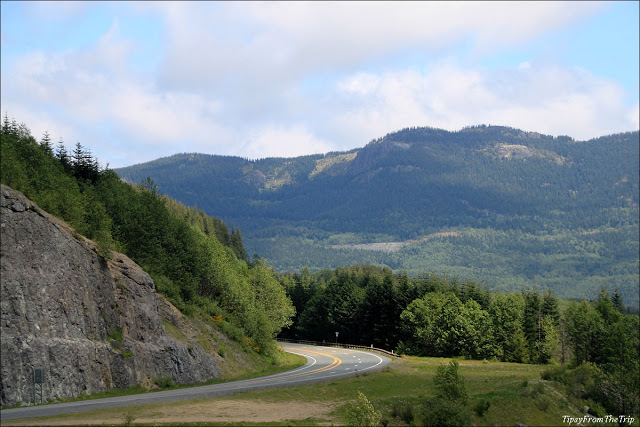
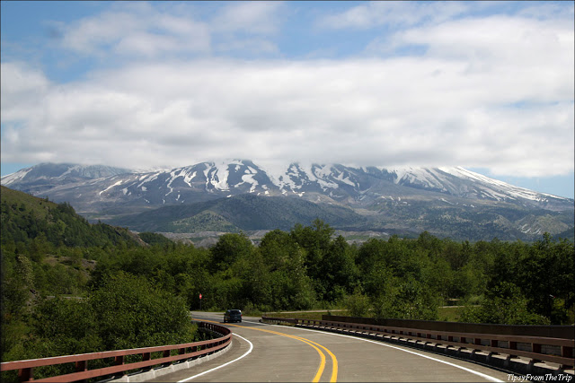
Spirit Lake Memorial Highway is Washington’s State Route 504 that goes eastward from Castle Rock, a small town that lies somewhere between Seattle, WA and Vancouver WA. This route meanders through lush green forests and several creeks that flow from the Cascade Mountains and into the Pacific. It is the ‘Evergreen State’ that we are talking about but when Spring is in its last leg, what you see around here is the greenest green.
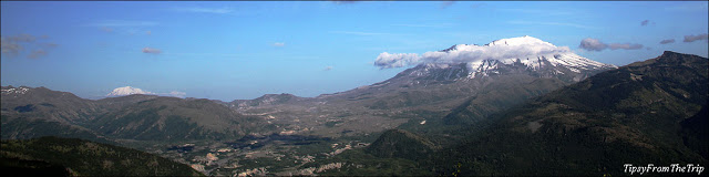
After fighting its way through tall green trees, Spirit Lake Memorial Highway took us through the mountainsides of the Cascade Range. There were several visitor centers and learning centers on the way, and all of them seemed to be located in points that offered scenic views. And with each stop the views only got better. Our first stop was the the first visitor centre, the one at Seaquest, I believe. Here I spoke to a naturalist for a little guidance on the way up and picked up map of the route. From this point I think I also got a glimpse of Silver Lake.
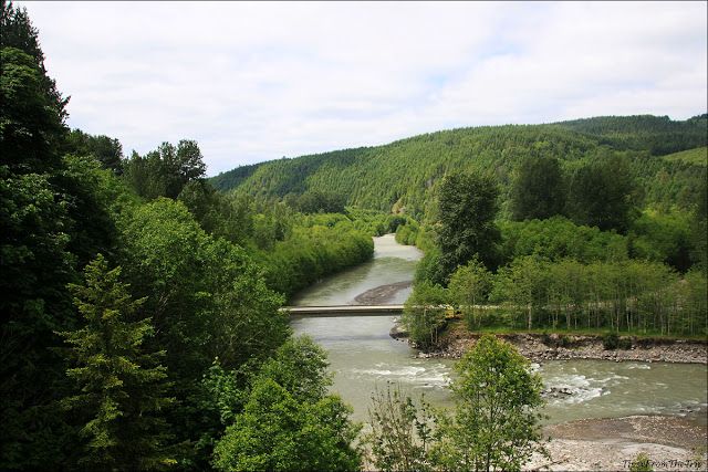
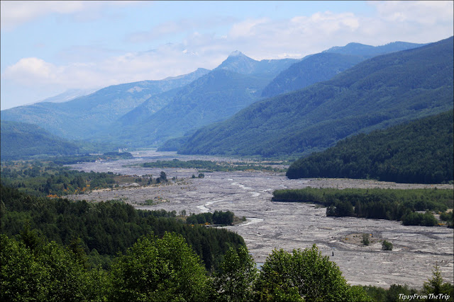
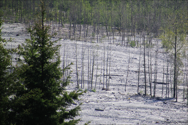
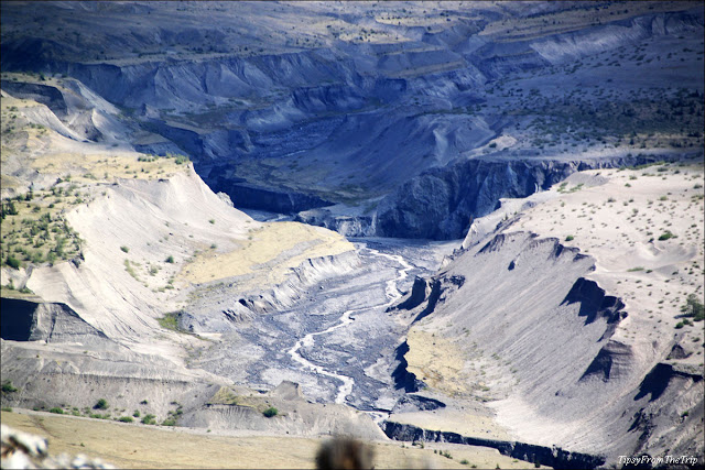
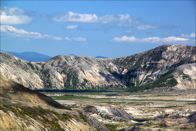
A little later, we stopped for lunch at homey little restaurant on the 19 mile and this place too was in a scenic setting. We looked out the balcony and saw the Northfork of the Toutle River calmly flowing by. Our next stop was Hoff Bluff and the scene here was proof of how devastating the eruption of 1980 was. But then again, the path of the lava is lined by such rich greenery on either side and that seemed to balance out the landscape.
Mt. St. Helens’ History
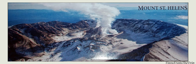
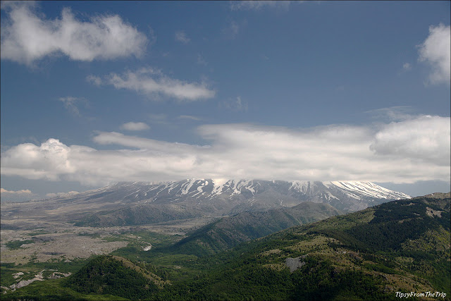
Before we go any further, let me tell you a bit about the volcano that was supposed to be the highlight of the trip. Mount St. Helens is an active volcano of the Cascade Mountain Range and it lies in the southern part of Washington State. It has had a catastrophic explosion as recent as 1980. In March that year, the volcano that had been dormant for 123 years awoke, triggered some earthquakes and started throwing up molten material. One of the information boards near St. Helens says that that time around, ‘the summit diverted the rising magma sideways pushing the north-face dramatically upward.’ A couple of months later, in May this tall north-face of the volcano collapsed and a lateral explosion also took place. As such, this is what St. Helens looks like these days:
Coming back to the drive and the views on the way, the vistas from the Hoffstadt Bluff were very telling. The pictures below will show you the path of the lava and the devastation that came about from Mt. St. Helens’ eruption.
Later, there was the Forest Learning Center’s viewpoints that laid before our eyes, the path from a vista point higher up than the previous one. This stop give us a better view and also told us about the Elk in the area. Although we didn’t get to see the animal that this point was famous for, the vistas it offered were more than photogenic.
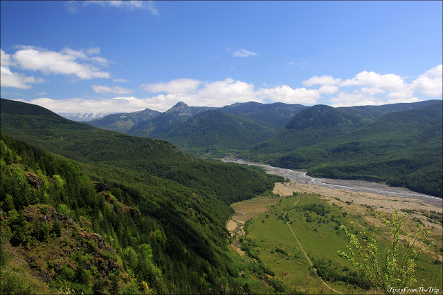
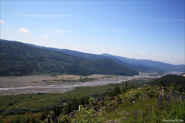
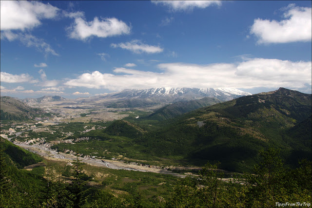
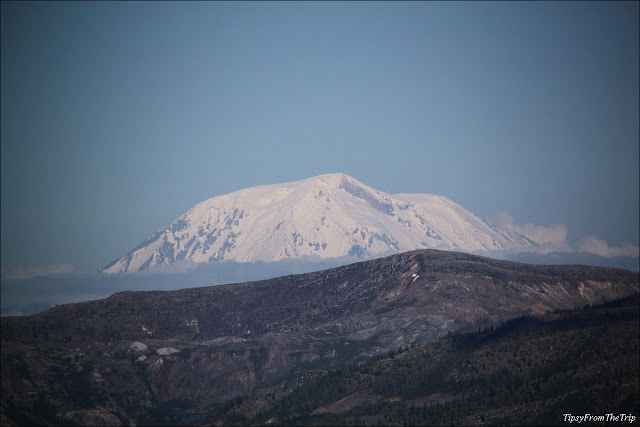
Further ahead there was another vista point, this one actually called Elk Rock Viewpoint. Did you know that Elk can actually thrive in Volcanic landscapes? Never mind, when you get to this point you’re probably more interested in the volcano nearby, than anything else. Or at least that was what it was like, for me. The reason I’m saying that is because this point showed me bit of the massive Mt. St. Helens that I’d been spying with my little eyes for a long time; albeit from afar. Mt. St. Helen’s is visible from parts of southern Washington even a good stretch of  the Interstate Highway (I-5), thanks to its height of 8,363 ft.
That said, I must add that when you are around there, there is no guarantee that you’ll see all of the volcano. There will be days when it might seem like the whole mountain has disappeared. The clouds and the fog around here can do a great job of curtaining the humongous Mt. St. Helens.
Having seen the volcanic mountain from that distance I-don’t-know-how-many-times, it was exciting to go towards it, to see what it looked like up-close. As we passed the points-of-interest along the road to Mt. St. Helens, many a time we got to see the route of the lava that flowed out of this mighty volcano. It felt like we were on a quest, following the lava path back up to the volcano that vented out all that flow. As we got closer to the mountain, the path of the lava looked more cut out, more defined; maybe the snowmelt also contributed to the sculpting of the course.
Loowit Viewpoint further up the route was like the almost-there-viewpoint. This place was just at the foot of the mountain and it offered clear views of the natural trenches that seemed to run down the mountain side.
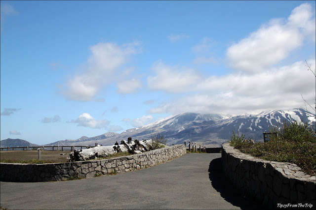
Loowit Viewpoint
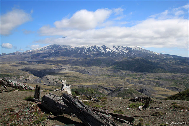
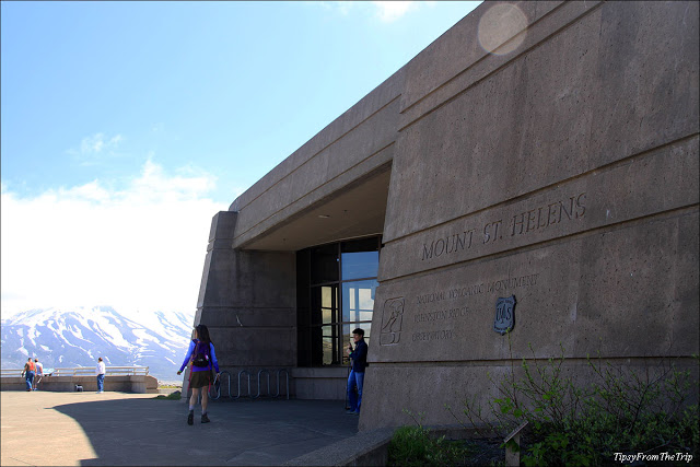
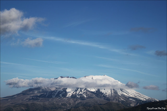
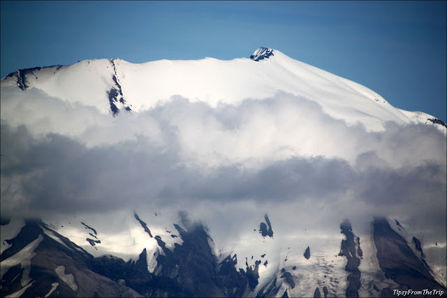
Another 3 miles later and we found ourselves at a parking lot just below the Johnston Ridge Observatory. This is the closest we visitors can get to the Volcano. And it is pretty close. Mount St. Helens was just a few yards away and we could see more of the channels that led away from the volcano. We could also see all the snow that continued to stay put on the mountain long after winter. We could even see the part of the mountain that collapsed in the big eruption of 1980. What we couldn’t see was the rim of the volcano as there was a large cloud refusing to show us all of Helens.
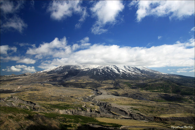
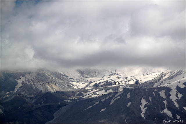
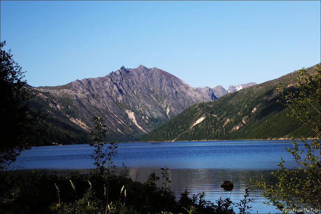
Having gone that far, and that close to the active Volcano, I wished to see a little more if it. So we waited for quite some time but that big cloud was as obstinate as ever. In the meantime I caught a glimpse of the dark-blue Spirit Lake that lay northwest of Mt. Helens, walked up a trail that showed me the volcano from another vantage point and even learnt more about the area and volcanoes in general, at the visitor center of the Observatory, all the while keeping an eye on that cloud that seemed to be playing spoil sport that day.
We had pushed our luck, and after all that loitering around, there was no sign of that thick cloud budging from its cushy seat. So then we did the only thing left to do, which was — drive back to Vancouver, Washington.
The connection between Spirit Lake and Coldwater Lake
On the drive down, we stopped at another POI and I took to the ‘Birth Of A Lake Trail’ to have a quick look at Coldwater Lake. This is a lake on the route of Coldwater Creek that flows down St. Helens. But it has an underground connection to Spirit Lake as well. Here’s what happened when the historic eruption took place in 1980: debris and ash were thrown in the direction of Spirit lake, blocking its outlets and damming the lake. To avoid an overflow of this lake which was likely to flood the Toutle Valley, a tunnel was dug so as to carry excess water into Coldwater Creek.
A few pictures later, I walked back and joined the family and we were back on the road. A few miles down, Mt. St. Helens was back in view and most of the cloud near it had moved away. And we had our best view of the day.
It was quite surprising because it was already past 5 pm and we didn’t have hopes of seeing the rim of Mt. St. Helens that day. However, when we were almost at Elk Rock we found that the view there had only gotten better. We decided to make a pit stop and I can’t tell you how glad I was to see that there was another surprise in store — a snowclad Mt Adams in the distance. I couldn’t ask for more, that day.
Did you know
(Mount St. Helens trivia):
- The native Americans called Mount St. Helens ‘The Fire Mountain’
- There were 2 eruptions in May 1980; one on the 19th and the next on the 25th.
- The 1980 eruptions darkened the sky around the volcan0. Places up to 250 miles around the mountain plunged into darkness after the first eruption.
- The explosion of the volcano was heard over 200 miles away
- The streets in nearby towns were covered with so much volcanic ash that people had to use snow plows to clear the way.
You might also want to visit:
Volcanoes of the Cascade Range
Other Volcanic Sites featured on Tipsy from the TRIP
For more fun stuff from the trips, follow Tipsy from the TRIP on Instagram.

Great photos and a fascinating place to visit. Very interesting to see how green so much of the countryside has become.
Thank you, Mick.
Very fascinating indeed. All the time I kept thinking about what a big event that last eruption must have been.
True, the greenery does stand out and contrast the dry devastated areas.
Thank you for visiting, Mick. 🙂
Wow never thought you could follow the lava trail. Looks like a trip worth doing. Remember it happening and reading some of the story’s from it. Nice work and photos
Hi Bill,
This is one place you can do that. 🙂 If you are on the Spirit Lake Highway, you keep seeing the trail off-and-on, on your way up. And there are so many viewpoints on the way. Oh yeah! So worth doin, provided the weather is on your side. 🙂
Thank you so much, Bill. 🙂
These are incredible pictures! I have never witnessed a volcano in my life, and I am really keen to see it on my own one day.
Thank you, Renuka.
These places are sowwww interesting!! You get to learn so much. And somehow you never get tired of volcanic sites.
Thank you for stopping by. 🙂
The scenery is just amazing and delightful!
True.
It makes for an awesome scenic drive. 🙂
When the volcano, Mt. St. Helens, exploded, I was living in southwestern British Columbia, very near the US border. I heard the explosion, but had no idea what it was, because I was living alone, and sleeping at the time. The eruption abruptly woke me up!
My neighbour had told me, two days before, that he was driving to Mt. St. Helens, and I was terrified that he might have been hurt or killed. Fortunately, he had decided not to go there.
The ash spread everywhere, and there was an air advisory in southwestern BC for a while. It was certainly more excitement than anyone in the Pacific Northwest could ever want.
Kay
An Unfittie’s Guide to Adventurous Travel
Whoa! It must have been really loud. And with those eruptions taking place in the morning, I’m sure a lot of people were jolted awake by the explosions. I can only imagine all the confusion.
Good that your neighbor had change of plans.
Thank you so much Kay, for sharing your experience. 🙂
What a great set of photos. The one time I was there it was foggy and we didn’t see a thing.
Thank you, Al.
Oh yeah — I know about the fog there. That happened to us when we visited Mt. Rainier. The fog refused to let us see the biggest volcano of the cascade range. I was so, so disappointed. 🙁
Amazing vistas captured!
They were amazing vistas indeed, Magiceye.
Wow, this was such an interesting post, and your photos are spectacular!
Thank you, Victoria.
Welcome here. 🙂
Beautifully written, love the way you have captured the beauty of the place.
Thank you Puneet. Welcome to Tipsy from the TRIP.
Hope to see you here again. 🙂
The native Americans called Mount St. Helens ‘The Fire Mountain’. A new information for me . What a lovely place it is to visit . Fantastic write up Divya Nambiar !!
It was a great place to visit. There was so much to see and experience. To learn, too. 🙂
Thank you so much, Yogi.
Beautiful part of the country. Wish to visit this someday.
Oh yes. The Pacific Northwest is gorgeous!!
You should. Just make sure you look up the weather when you plan the trip. My trip to Mt. Rainier was so disappointing. It was so foggy and snowy that we couldn’t drive beyond a certain point and the fog didn’t let us have that view from afar, too.
Thank you for stopping by, M. 🙂
Wow !!!! amazing captures…informative as well.
Thank you, Jyotirmoy. 🙂
Amazing pics. Great post.
Thanks, Rupam. 🙂
Truly scenic. Lovely pictures.
There is such a lot to explore!
Had travelled to Washington DC, but at night.
Absolutely.
Thank you, Anita.
True — so much to explore and not so much time. 🙁 🙂
This place is in Washington State on the west coast. 🙂
wow, time flies fast. Is it that long ago?? I remember it like yesterday. Great shots and nice to see nature recovering 🙂
Does that seem like fast, Monica? It’s like my whole life. I was born that year. 😀
Thank you so much, Monica. 🙂
As a resident of Montana, I am a big fan of mountains and the Northwest, so this post was right up my alley!!! Isn’t it amazing that the lava flows in the valleys can still be clearly seen, almost 40 years later? I appreciate your persistence for a photo of the peak of Mt. St. Helens – it paid off!
Thanks for your recent visit to my blog and your kind comments!
I’m sure. When I read your post about your move to Montana, I was thinking that was so COOL!. 🙂 I hope to see more sights from there on your blog, Angie. 🙂
The greenery near Mount St. Helens is truly amazing.The rains that the Pacific Northwest gets has definitely left a mark in the area. And the soil in volcanic areas are supposed to be very rich too, is it not?
Thank you so much, Angie.
So beautiful pictures and written !
Thank you, Shrey.
These are some fabulous photos of the area. What diverse scenery.
The scenery here is just gorgeous.
Thank you, Betty. 🙂
I have never seen volcano…The pictures took me there.
Now you have, Ranjana. 😉
Wow WoW Wow…this place is insanely beautiful….would love to visit it someday…i have only seen the active Volcanoes in New Zealand and it was a great experience
Very interesting. Very fascinating, too.
I can’t get enough of places like this.
Come on over. 😉
Looks amazing 🙂
And it IS amazing. 🙂
Thank you, Joshi. 🙂