Several Springs ago, we had driven to the top of Mt. Hamilton and seen Santa Clara Valley from a height of 4,200 odd feet. Then last Fall, in what was like a follow-up trip, we drove up the same range, this time to the top of Hamilton’s little brother Mt. Diablo, which lies further north of it.
Mt. Hamilton and Mt. Diablo are among the popular peaks of the Diablo Range that lies stretched east of the San Francisco Bay in California. The chain of hills that make up this range is not too high, so a trip to one of the taller summits means wide-angle views of the characteristic rolling hills of the range and the great plains that lie beyond it.
This drive to the top of Mt. Diablo was not unlike that trip to the top of Hamilton: the highway snaking up the Diablo range through a series of twists and turns and serving us with panoramic vistas of the low rolling hills around it. On a lucky day, I hear you can even see the more famous Sierra Nevada range, which lies to the east.
As we went further up, we were shown rooftops and treetops and eventually hilltops and telescopic views of ups and downs and converging rivers. Here is a photo tour of that scenic drive:

Taken somewhere on the way to the top of Mt. Diablo. 
From a higher elevation.


At one point we stopped to lay our eyes on Livermore Valley. I’ll say nothing more about it; these pictures speak for themselves:


Our destination – the top of Mt. Diablo and the Summit Visitor Center 
The Summit Visitor Centre, a structure built of stone is by itself one of the attractions at the top of Mt. Diablo. 
Mount Diablo’s Beacon
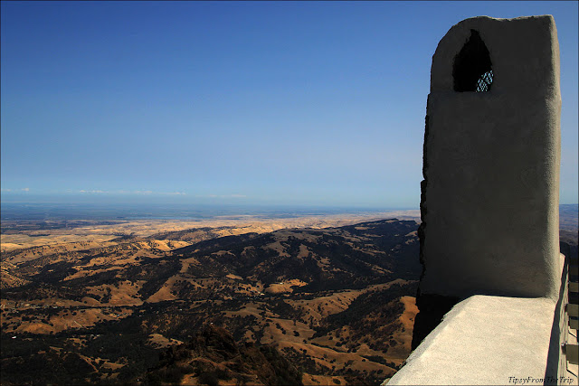
Undeniably, the biggest attraction here is the view. Here are the views from the top of Mt. Diablo, which is over 3, 800 ft in elevation.

Read about the ‘linguistic accident’ that might have won Mt. Diablo its name, here —

Views from the top of the observation deck above the visitor center:


Must do while you are here–
Bring a picnic lunch and enjoy it in the almost- private picnic tables you find at by the side of the road that takes you to the top of Mt. Diablo.
(From where we sat, we could see the stone building at the summit on one side and on the other, the Sacramento River just before it joined the San Joaquin River and some windmills near there. )
You might also like:
— The views from Mt. Hamilton
— The Patterson Pass drive (also on the same mountain range)
For more visual treats from ‘viewpoints’ click HERE.
Linking to Our World
For pictures from the road,Like/Follow Tipsy From The TRIP on Facebook.
Come, Trip with us. 😉


Beautiful views,inviting scenes!
Aren't they?
Nice to see you here, Indu. 🙂
Wow amazing. Great pics.
🙂
Thank you, Rupam.
Were you able to see the Half Dome? It is said that on a clear day, you can see as far as the Half Dome. I would like to come back in the wintertime to see how different the scene is.
I've heard you can see the Sierras and the even parts of the Cascade Range. I didn't know the Half Dome was distinct from here. So cool! Spotting that sounds exciting! Thank you for letting me know, Maria.
I'd love to go up there one haze-free day to catch sight of more.
Good luck to you too. 🙂
Beautiful frames of the gorgeous vistas!
Gorgeous they are.
Thank you, Nomad. 🙂
reat place to perch and take pics.
Thank you for showing these lovely scenes.
I love views like this. 🙂
You're so welcome, Indrani.
Some of your travelogues are a treat to the eyes. Thank you for the glimpses of the 'Devil Mountain', and an almost glimpse of the Sierra Nevada range. The script goes hand in hand with the images.
It's always such a pleasure to hear what you have to say. Thank you so so much USP for coming this way. 🙂 I hope you are having a good week.
Stunning captures. Thanks for sharing 🙂
Thank you so much, Purba.
The pleasure is mine. 🙂
That's quite a view; amazing! Great pics!! It is a good choice for a one-day outing, I'm sure. Just that I'm skeptical about the heat. Thanks for sharing 🙂 🙂
Isn't it? Even the drive to, and the views from Mt. Hamilton are great. And Hamilton is closer to where you live.
Yeah, both Mt.Hamilton and Mt. Diablo are great for day trips from anywhere in the Bay Area. And the heat is pretty bad now; might as well wait until Fall. And don't forget that picnic lunch, huh. 😉
Noted, chechi. Waiting for the summer to pass…
That would be the perfect thing to do, Shal. I hear that triple-digit temperatures are returning to these parts. Ouch!
Diabolically breathtaking views indeed!
😀
I second that thought.
Good one, Magiceye.:)
spectacular and breathtaking views of from such dizzying heights…
I have to agree with you.
And Welcome here.:)
Loved the photo tour. The light is amazing.
I'm so glad to hear that, Kalpana.
Thank you so, so much.
I have been here, Dee. Lovely clicks. You brought back some awesome memories.
Yeah? Nice to know that. 🙂
Thank you, Rachna. 🙂
Wonderful captures! It was indeed a great photo tour 🙂
Thanks Arun.
I'm so glad to hear that. 🙂
The view from the top is just stunning!!
Isn't it?
Thank you for coming by, girl(s). 🙂
Love the pictures in your Mahamasthakabhisheka post. 🙂
Very interesting place! 🙂
The scenes from the top were the icing on the top. 🙂
[…] up of pretty-low lying rolling hills that are dry for the most part of the year. The post — Vistas from California’s Devil Mountain will show you what the mountain range looks like when it is in it’s dry stage. Come winter […]
[…] Vistas from California’s Devil Mountain – Mount Diablo […]
[…] to Our World&My Corner of the WorldMore: From this State Park–Vistas from California’s Devil MountainSee also:Shasta CavernsRocky Attractions on Tipsy from the […]
[…] Diablo Range —Round Valley Regional PreserveBrushy PeakMission PeakFranco Ranch LoopMt. HamiltonMt. Diablo More:Bay Area […]